One of the most popular ecotourism destinations in all of Newfoundland & Labrador is the gannet colony at Cape St. Mary's. Thousands of people take the short hike every summer to overlook the tens of thousands of breeding gannets. The sights, sounds and smells of Bird Rock are simply overwhelming.
Far fewer people have visited Bird Rock by boat. Many fisherman and the odd group of kayakers have marvelled at the panorama of a sky filled with northern gannets and the overpowering noise of all their squawking. I won't even try to descibe the odor!
Paddling around Cape St. Mary's has been a goal of mine for many years. The headland juts out from the south coast of the Avalon into the northwest Atlantic. It is usually battered by winds and huge swells ... but if you pick your day, you can enjoy brilliant sunny weather, calm seas and no more than a gentle breeze.
September 18, 2007 presented just such a day. I contacted several experienced paddling buddies, and Ian Fong of St. John's and Jonathan Walsh of Placentia were interested. The forecast looked excellent.
 We decided to start from St. Bride's and finish at Point Lance, 25 kms in all (click on map and photos to enlarge).
 Here are Jonathan (aka pastey white guy on left) and Ian Fong (aka the Fongman) getting ready to go in St. Bride's. We began at 11:30am.
 Almost the whole coast along our route was seacliffs (200 - 300 feet high). Here we are approaching Island Head, south of St. Bride's.
 Here's the narrow passage through Island Head. We were lucky to have ideal conditions. The swell was less than 1 metre, the winds were very light, and the sun was splitting the rocks.
 We carried on to Norther Head and played in the swell running through the rocks and stacks. In the distance you can spot the Cape St. Mary's lighthouse on the cliff top. We stopped for a quick lunch just inside Lears Cove.
 In Lears Cove, we found this excellent camping spot, which had 2 streams and level areas for many tents.
 Nearby, we found this very narrow passage between the cliff and a tall seastack. The swell was magnified going through the passage to several metres. You can just see Ian's yellow shoulders disappearing in front of the surging wave in the photo. Exciting!
 The seacliffs were amazing all along the route. Here's Jon in Brierly Cove.
 This photo, looking north into Brierly Cove, shows how calm it can be on a good day.
 As we pulled further south, the Cape St. Mary's lighthouse came into clear view.
 The Fongman just had to celebrate the moment with a few antics!
 And here we were at last, paddling around Cape St. Mary's!!!
 Just under Bird Rock, we discovered these towering caves.
 Here's the view looking out of the cave. The sky is full of flying gannets. It was silent in the back of the cave, except for the swell. As you paddled out of the cave, you were hit by a wall of noise from the gannet colony just above. Incredible!
 Here's Jon below Bird Rock.
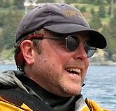
 Here's a close-up photo of the adult gannets (white) and the large gannet chicks (brown).
 From the big smile on Ian's face it's not hard to tell he was enjoying the trip.
 We paddled further east and entered Golden Bay. There we found a sandy beach with gentle surf. We couldn't resist. We each got in a few runs in the surf before stopping for a break.
 The beach at Golden Bay is beautiful, but not very accessible. It's a long hike from Cape St. Mary's. Unfortunately camping is not allowed here, as the beach is located within the Cape St. Mary's Ecological Reserve.
 Paddling east out of Golden Bay with Bull Island Point in the distance.
 Rounding the point and entering Lance Cove, the village of Point Lance came into view.
 Luckily, there was another long sandy beach in Lance Cove, so we did some more surfing to end the paddle on a high note.
 About all we could say after such a marvellous day was Wow! This paddle was definitely a highlight of the 2007 season.
If you are interested in looking at more photos from this trip look here http://205.251.50.54:3500/neilcape07/index.htm on my buddy Tony Lee's great website http://www.kayaktherock.com/
Including our stops, the paddle took six hours (11:30am - 5:30pm). There were only the 3 spots mentioned that were good for stopping. There were many other small pocket beaches that could be used as landings (only on a calm day), but the cliffs above do not provide any escape.
The sea conditions and light winds on this day were well within Level 2 conditions, but the high seacliffs with very few landing spots make this a Level 3 or 4 paddle under ideal conditions. On average, there are only one or two days each month with ideal paddling conditions at the Cape.